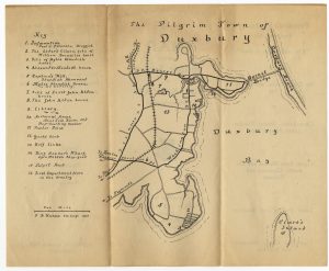
Peterson’s Map of Duxbury
Map of Duxbury, 1921
Paul C. Peterson
Duxbury, Massachusetts
Ink on paper
DAL.SMS.090, Ephemera Collection
This map from Peterson’s Pharmacy advertises his business as well as showing tourists and summer residents where a number of historical sites are located around town. The map was designed by F.B. Knapp, then proprietor of the Powder Point School for Boys that operated as a hotel during the summer months.
Paul Chester Peterson (1883-1950) was born and raised in Duxbury. He became a clerk at the pharmacy of Nathan Stetson, eventually buying the firm, in 1907. As a pharmacist, Paul C. Peterson was an entrepreneur, he initiated a mail delivery for his customers, sold post cards and maps of Duxbury, and imported souvenir pottery. See examples of this type of souvenir pottery in Collecting in a Pilgrim Town.
Digging Duxbury
The quest for archaeological evidence of the Pilgrim past began with an 1833 dig, one of the earliest in U.S. history.
Coming to a Pilgrim Town
Coming to a Pilgrim Town
Duxbury’s Pilgrim history, combined with the town’s natural beauty, initiated a tourist boom.
Collecting in a Pilgrim Town
Collecting in a Pilgrim Town
The tourism boom brought another enterprise, the creation and sale of Pilgrim-themed souvenirs.
Lasting Legacy
Duxbury's Lasting Legacy
Duxbury never forgot its Pilgrim origins. How could it? The names continue to generate interest today.
Return to Exhibition Main Page.


